Mapping Mazama Ash

Ancient Oregonians looked out to a horizon dominated by Mount Mazama. They hunted in its shadows, fished in its streams, gathered food in its foothills. Then, 7,700 years ago, their mountain erupted in an explosion so powerful that its whole peak collapsed. Twenty-four cubic miles of rock and ash smothered the land nearby and traveled on wind currents north and east for hundreds of miles. The hole left behind became the deepest inland body of water in North America: Crater Lake.
But what happened after half a mountain of rock went airborne?
That question sparked one of the most remarkable explorations undertaken by soil scientists in the Pacific Northwest, and what they discovered decades ago helps us understand the landscape in which we live today.
Oregon soils are a product of eons of volcanic activity rearranged by wind and water. Soils that form from volcanic ash have the capacity to hold large amounts of moisture and a tendency to bind phosphorus so tightly that the nutrient becomes unavailable to plants. When Moyle Harward joined the Oregon State University faculty in 1955, he suspected that farmers and ranchers were experiencing the effects of Mount Mazama’s transmutation in their fields. But no one really knew how much ash there was or where it lay. So Harward set out to map and characterize the soils that formed from Mazama ash. He and a crew of graduate students and postdoctoral fellows traveled all over eastern Oregon and into Washington and Idaho looking for Mazama ash.

- In this circa-1970 photo, Harward Moyle explores deep layers of volcanic ash that he revealed to be remnants of ancient explosions. Photo by Del Dingus.
Out in the field, his Ash Crew roughed it, getting up close and personal with the landscape they were studying, digging holes for their backsides to make sleeping on the ground more comfortable. “Soil science is a dirty business,” Harward laughed years later.
“Moyle opened my eyes to a whole new world,” remembered Bill Harris, who was a Ph.D. student in 1972. “He talked about volcanic ash, mountains, trees, and Oregon State as the place to be. I could hardly wait to join the Ash Crew.”
Unlike soft, smudgy wood ash, volcanic ash is hard and abrasive, and it won’t dissolve in water because it’s actually tiny pieces of rock. “You pick up a fistful and it feels dry, but when you squeeze it, water drips from between your fingers,” said Ash Crew member Del Dingus, who later became a professor of soil science at California Polytechnic State University.
Harward and his crew first started looking for ash in the direction that the pumice had flown during Mazama’s eruption. They located airfall deposits a foot thick as far as 300 miles to the northeast of Crater Lake, but there was little ash in the center of the state. When they found deeper deposits in gulches and gullies, they realized that the ash had eroded from some areas to collect in others. In collaboration with other scientists, they determined that a lot of Mazama ash had been flushed down the Columbia River, forming sediments near the river’s mouth.
OSU scientist Henry Hanson, who specialized in the vegetation history of the Pacific Northwest, led the Ash Crew to peat bogs where the volcanic ash had settled in layers, undisturbed for millennia. Harward’s team took samples from each layer and used sonic vibration to knock volcanic glass off the ash particles. Then they stuck the naked ash particles in a reactor to create radiation patterns that served as signatures from specific eruptions. In this way, Harward’s team was able to distinguish ash from Mazama or Newberry in Oregon, or Glacier Peak or Mount Saint Helens in Washington. And they found evidence for two, back-to-back Mazama explosions preceding the crater formation.

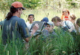
- OSU soil scientist Jay Noller encourages his students to understand the landscape by drawing it first. He combines field observations with data from satellites and elsewhere to create highly detailed digital soil maps. Photo by Lynn Ketchum.
Today, Jay Noller leads OSU’s next generation of soil mappers. He and his crew study the interrelationships of soils with the environment, in particular the volcanic soils that underlie the extraordinarily productive forestland here in the Pacific Northwest. “Globally, only about one percent of ice-free land areas have significant levels of volcanic soils,” explained Noller. “Basically, the Mazama eruption fertilized what was once scrubland—the forests are here now because of the volcanic ash.”
Using new technologies informed by the discoveries made by Harward’s Ash Crew, Noller’s students can predict the characteristics of soils across the Pacific Northwest and the impact of those soils on landscape features. Soils rich in volcanic ash have a lower surface area and greater air permeability, so they tend to form water-repellent layers. When wet, the ash can form gels that flow, so soils with bands of ash—such as those underlying our Cascade Mountain passes—are prone to slide and shift. Volcanic soils don’t retain heat well, so they tend to be cold if they are in shadow, creating a mosaic of microclimates.

- Every soil pit has a story. In this circa-1970 photo, soil scientist Moyle Harward (emerging from the pit) regales his crew with stories of ash falls that blanketed the Pacific Northwest. Photo by Del Dingus.
“The best field scientists—like Moyle Harward and Jay Noller—are great observers, artists in many ways,” said Russ Karow, head of OSU’s Department of Crop and Soil Sciences. “They know their subjects well enough that slight differences in color or shape become meaningful. Now, new technologies may give machines that same ability to sense fine differences and use an extensive detailed database to predict soil characteristics.”
Harward turned 90 in May 2012, and he and his Ash Crew still get together every so often. To share their enthusiasm for soils, the crew made nearly $30,000 in personal contributions to OSU, enough to endow a lecture series that honors their mentor. The first Harward Endowed Public Lecture took place in January 2012, entitled “The Joy of Looking at Soil.”
